Sunday, July 13, 2014

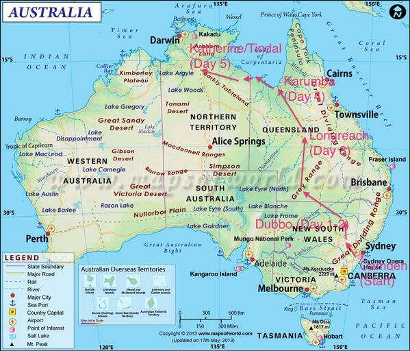
Day 5 - Karumba YKMB to Tindal/Katherine YPTN

Day 5 - Karumba YKMB to Tindal/Katherine YPTN

THE STORY SO FAR:
Woke up early in Karumba point and had a light brekky (toast, some orange/passionfruit juice). We trooped out to the airport, and got there by around 7:45am and started loading the airplanes. I did a preflight. I've noticed that the tour pilots don't do full preflights - I suspect because they were the last people to fly the airplanes, and because they're doing much more streamlined ones - but I have no desire to skimp. I'm well aware of my baby pilot status, and I have a strong desire to have an 'incident-free' flying career.

SDN was in good shape. I sumped the tanks, since we'd fueled at YNTN and flown over to YKMB - so there was some empty space in the tanks, and just in case condensate had formed. Nothing; all clean. Checked the oil - still at 8 quarts, she doesn't seem to burn much oil either. My pax removed the tiedowns while I removed the pitot cover and intake covers, then I did a walkaround. All was well. I shuffled another day of clean clothes into my day bag (my main bag is too big to horse into town every night, so I tend to just stuff a day of clothing into my CPAP bag and bring that plus my gear bag). Filled out movement and fuel logs, then we got into the plane and ran through checklists.

While I was doing that, Val took off in ULE. I managed to get started before Hugh in IRJ, so I took the runway next and we took off to the west, turning right a bit to head up the coast. The day's flight was the complex one involving arbitrary waypoints, but (hooray!) I'd programmed them all in during the flight up from Longreach yesterday and assembled them into a flight plan in the G1000. I hand-flew it, though - went to 500 feet for a while, then 1000 feet. We followed the coastline for around 250 NM, flying along mangrove swamps and inlets and a couple of river deltas. It was gorgeous - the Gulf of Carpenteria on the right, and bright turquoise water along the shore, with mangrove trees stretching all the way out into the gulf itself. In that 250 miles, we saw one road, which I found out later was a recent addition, probably by the military (dirt); some 4-5 speedboats, and nothing else. No habitation. No houses, no roads, no power lines, no railroads, nothing except mangrove swamps and the bush. As an American, especially one from New York, this completely blows my mind.

Afer 250 NM, we turned inland and flew 50 miles or so to Borroloola YBRL, a tiny strip at a bend of the Macarthur River. The wind had picked up, and we landed with perhaps a 10 or 12 knot direct crosswind, and taxied back to the tiny apron at the approach end. There was a fuel bowser there, but it turns out the credit card system on it was malfunctioning. I had enough gas in SDN to make it to PTN, most likely, but the 172s don't have that sort of range. Luckily, the fueling chap was there working on the generator that runs the bowser, and he got on his mobile and got us authorized. I had a bit of trouble - my debit Visa cards really don't work well over here, it seems. I'm not sure if it's because I've been fraud-checked or not, because my bank does not have a frigging non-toll-free number posted on its website so I can't even call them to check. Grrmmrtrmbl. And none of the machines take Amex. Fortunately, my pax had a working Visa, so we fueled up.

After fuelling, we sat at the picnic table which was the extent of the ground facilities at YBRL, had some cheese and salad sandwiches we'd brought with us, and walked the 1/4 mile to the 'main streat' of Borroloola. Um...well, there was a petrol station. And a motel. This is somewhere that is probably 300 miles by road from any other larger settlement. The police cruised by and waved, probably concerned that there were suddenly 9 people with no visible means of support or, worse, cars wandering around town. We headed back to the airstrip and mounted up.

The second leg today was a straight flight across country. We headed almost directly west to Tindal Airbase, a RAAF base which doubles as 'Katherine Airport' (at the other end of the field) a tiny airport for the town of Katherine some 8 miles away. The flight took us over several fires - I was told by the locals that these were likely ranchers burning out areas to improve grass growth, although one of them looked to be a eucalyptus fire next to a river - billowing white smoke, rising up to 6000 feet or so. We were at 4500, but didn't pass directly through it, so I didn't divert.

The ride got bumpy at 4500 - we had a 20kt quartering tailwind, and there were just enough hills below to cause some bumps as the wind came through. I decided to avoid climbing, as it wasn't too bad - SDN had no trouble. Since it was Sunday, we were pretty sure Tindal wouldn't be active, but we checked as we got closer - sure enough, Tindal was closed down, operating as a CTAF. I had pulled ahead of the pack as they were not only slower, but had climbed to 6500 to get out of the chop, so I went in first and landed. Nobody there. There were a couple of dozen aircraft shelters under the downwind leg, but they were all locked up tight - nobody was visible anywhere on the airport. The RAAF, I was told, doesn't really operate on Sundays. I'm not sure how tongue in cheek that was (or wasn't!)

Taxied over to the civil apron to the fuel pumps. Hooray, it's a Shell Aviation pump, so the fuel carnet from SDN worked. Gassed up, then taxied over to transient parking and tied down between a pair of local 172s and a Piper of some make or other. While we were tying down, Val landed in ULE. She dropped her pax at the airside gate to the Katherine terminal, and SMSed us to tell us that getting out of the airside required an ASIC holder to hit an intercom. So we legged it over there when Hugh came in and got out with his crew while Val and Hugh went to fuel up and tie down.

We got a van taxi into Katherine, and here we are at the Beagle Motor Inn on 4th street. Walked into Katherine - there is a shopping center with a Woolworth's in it (Woolie's, in Aussie) but everything else in it (bar a chemist) was closed. We walked up the main drag in Katherine - two blocks of local stores, then BAM the bush again. The main street through is a highway - the sign says '<--DARWIN ALICE SPRINGS-->" on it at the crossroads. "Hey, isn't Alice Springs like a thousand klicks or something from here?"

"Yeah, but it's that way, mate."

Okay.

Was saddened to see that the population of Aboriginal people in Katherine seems to have the Native American disease - many of them were sleeping off liquor on the roadsides. Somehow felt guilty about this. I suppose showing up with an airplane makes me feel like the technocrat invader.

Time to figure out tomorrow's flightplan and make some notes. I've flown perhaps 1600-1800 nautical miles of Australia. It's a beautiful and empty country. More later.

Day 4 - Longreach YLRE to Karumba YKMB

Day 4 - Longreach YLRE to Karumba YKMB

Woke up for an early breakfast at 6:30 in Longreach. At 7:30 we walked back over to the airport, passing under the regal form of the City of Bunbury (the Qantas 747). Preflighting went smoothly, and we prepped the airplane for a long-ish leg of 390 nm to Normanton YNTN, where we would refuel before a quick 19 mile hop to Karumba, our destination for the day.

We were the first airplanes off YLRE. Val, in VH-ULE, took off first. Hugh, flying VH-IRJ and us in SDN took a few more minutes to run through checklists. One thing about having a glass cockpit, is that like too many other computers, you have to wait for the thing to boot before you can do anything. On a steam gauge airplane, you can run through the checklist almost as fast as you're comfortable doing so safely - on the G1000, there are at least two points where you're essentially sitting there waiting for a POST and boot before you can check readings.

We took off second, and headed out across northern Queensland. Val had given us a card to post in SDN with the aircraft reg numbers and pilot names (tickled, still, to see myself listed as pilot - I'm basically a kid, in that respect, and I hope it never changes) and the company frequency for tour chat.

We all settled in to cruise. We were making around 135 kts across the ground, and Val and Hugh were making perhaps 115 - they are flying 172s, with 4-cylinder 180HP engines and fixed-pitch props; we have 230HP in SDN, with a 6-cylinder Lycoming and a variable pitch prop. As a result, by fiddling with engine leaning, I am managing to get 135 kt cruises on 10.5 gallons/hr fuel burn, on a heavier airplane. That's about what I burn in N12732 back home, a 172 with a lower MTOW.

Northern Queensland is suffering from drought, which is quite apparent from the air. The country is dry; watering holes are low or dry, and there is very little cattle evident, as most of them have been rounded up and taken elsewhere where there is more fodder and water. Or slaughtered, I suppose, in some cases. Empty water holes surrounded by cattle tracks were abundant.

We're actually quite far into the Australian interior, at this point, and it's evident - almost no roads. In the 390 NM leg, I think we crossed a single paved highway (which had no traffic visible). Very few structures - some temporary or utility structures for ranching, and a few stations were visible, but not many.

Around halfway, we caught up to Val in ULE. I had elected to fly at 4500 while she and Hugh were at 3500, partially for that reason - I figured it would be easier to avoid unpleasant surprises by leaving a thousand foot buffer between us. We eventually did find her, though - and the G1000 stubbornly resisted my attempts to edge over to the right a bit to maintain a line of sight to ULE from my side of the plane, until I shut off the autopilot and swung wide. After passing them, I got back onto the projected course track.

I'm not using paper charts in the airplane, much. I have them ready, but I'm not performing the required minimum-every-thirty-minutes position check on the paper. To be honest, Australian charts are kind of crap, if you're used to American sectionals. They have very little information on them - although they have airfields marked, they don't have navaids, and they have no airfield information on the chart itself - no frequencies, no navaids, no runway info, etc. They may have field elevation, but that's about it. The rest of the chart - no highways, obstacle markings/clearances, anything. Railroads and some power lines are marked, but very few.

As a result, I am relying on electronics. I know this is bad, but I'm not doing so without backup. The G1000 in the plane is my primary - it has redundant systems. In addition, I have (and have verified functionality of) OzRunways on my iPad, and general GPS mapping on my iPhone. All of those work fine. The airplane has a power outlet, so charge isn't an issue. OzRunways, to be honest, gives me pretty much exactly the same functionality as the G1000 system, with a much better user interface. The only things it can't do involve connecting to other aircraft systems. But for navigation, it's excellent- better, in fact, than the U.S. app ForeFlight, which I have always considered to be an excellent example of an aviation app. It still is, don't get me wrong - but OzRunways just feels easier to use and read. It has other neat features, like firing iOS alerts when your course track indicates that you should switch to a different area frequency. Best of all, it has a thirty-day free trial, which just covers my trip here.

After a long leg, we arrived at Normanton. As I was approaching from the southeast, another aircraft announced that they were leaving Karumba for Normanton, and we would be arriving roughly simultaneously. This is a trend - most airports I've visited here, this has happened, generally with us being the only traffic for twenty minutes in either direction.

Coordinated with them (Tango Mike Quebec) and let them know that I'd be doing a full circuit, so if they were going direct, I'd be happy to stay behind them. That worked - by the time I was flying an upwind to eyeball the runway, they were landing. As we passed even with the runway, my pax said "That's a pretty big plane." I looked over - indeed, they were backtaxiing, and the shape was...not only big, but...

"That's a DC-3," I said, although uncertain of the veractiy of this due to their rarity.

"It's big, all right."

We came around and landed (my landings are improving, I'm pleased to say - they weren't ever unsafe, but they were inconsistent - as I fly SDN more, I'm learning what a proper approach looks like, and as a result the landings are getting better. Making the turnoff midway down the runway, I looked over - and it was a DC-3. A shiny one with bright markings. I pulled over next to the othe raircraft parked there, an older 182, and shut down. My pax headed off the field for a smoke, and I of course headed over to ogle the DC-3. She was marked up as 'Nostalgia Airlines' which seemed appropriate. I chatted up the gents from the other 182, who were also there to ogle her, and we took a few pictures. By that time, Val had arrived and ambled over, hoping that the Mobil truck which was by then fueling the DC-3 would have enough juice left for us!

Fueling at YNTN means calling ahead to call out the fueler. I was glad both that Val had taken care of that, and that it was a Mobil truck, which meant I could use the carnet card that came with the airplane.

After fueling up all three of us, the truck left. We all stood on the tarmac and watched as the DC-3 fired back up, taxiied out and took off, then got back in the planes for a quick 15 minute hop to Karumba. Stayed at 1500 feet for the trip.

Two things about Karumba - one, the DC-3 had gone back there, and was again waiting for us as we landed. Two, it's on the coast. The airstrip is perhaps fifty yards from the ocean. The north coast. I've made it to the north coast of Australia (albeit within a Gulf). The weather is lovely, the beach is pretty, there are pelicans and fishhawks and other birds - and a big sign warning that this beach is populated by crocodiles, and that failure to heed the warning on the sign can lead to injury and death and dismemberment, as crocodiles are dangerous.

Yep. Still in Australia.

Tomorrow we're doing a flight along the coastline for a couple of hundred miles. Finally got the GoPro mounted in the airplane today, and took some test video - I think we got the departure from Longreach, and we got most of the intervening leg using the timelapse function, but the battery died before we landed at YNTN. Hopefully I'll get some video of the coast.

One thing I did manage to do on the way here was figure out how to input arbitrary coordinate waypoints into the G1000, and then assemble them into a flight plan - so I should have our whole scenic flight programmed into SDN at this point. I'm not sure yet if I'll try to fly it myself, or if I'll hang back behind the tour pilots by cruising slowly, and let them lead. Probably the latter.

More tomorrow!

Friday, July 11, 2014

Day 3 - Dubbo YSDU to Longreach YLRE via Thargomindah YTGM

Day 3 - Dubbo YSDU to Longreach YLRE via Thargomindah YTGM

Woke up early early in Dubbo today, hoping to see clear sky. When I left my room to get breakfast at 6am, it was still dark, but there were clouds visible in the faint reflected streetlights. We were a day behind the tour - they had made it to Thargomindah, some 370 miles northwest of us, the day before. We had been stuck. Today, they were leaving Thargomindah around 8am to go to Longreach, some 275 miles further north. We were intent on catching them up.

Breakfast (a McDonald's coffee and McMuffin since they were the only thing open) and then a cab to the Dubbo airport. Felt sort of cool bypassing the terminal and coding in the GA gate. We walked over to SDN where she had patiently waited for the grounded day. Took out the stakes and tiedowns, did a preflight check, repacked our gear. The clouds were indeed overcast, but the Dubbo AWIS system claimed that they were at 3,700 feet (Dubbo is at 935 feet) - and far off to the northwest, we could see a strip of clear sky. Decided that we were going.

Fired up SDN, taxiied out to runway 31, did the runup, and took off. Turned on course at 1000 AGL, set the altitude bug for 2500 feet to remain below the clouds, and settled in. As the day broke, the flight, I realized, was AWESOME. 1500 feet AGL we could see everything! We passed over farmland, pasturage, sheep stations, and a lot (a whole lot) of bush, i.e. scrubland and red dirt.

We were heading to Bourke YBKE, around 160 nm out, which had been our goal the day before. Got there in good time - winds were much better, and we made around 132 knots over the ground. At Bourke, we were doing fine, so I continued on to Thargomindah YTGM, some 188 nm futher on. We had come out from under the clouds, so I climbed to 6500 feet in a completely clear blue sky, the sun coming up in the East over our right wing.

I was struck by how little traffic there was on the radio. I was listening to both the local CTAF frequencies and to Brisbane Center (Melbourne to start, Brisbane as we tracked north). There was only occasional traffic, most of it from commercial flights up at flight levels 190 to 350, or approaching/departing Sydney and Brisbane. US frequencies would be full of traffic, requiring clipped comms and care to avoid stepping on other transmissions, but here, nope, long long stretches of silence.

Approaching Thargomindah, I called my approach on the CTAF some 25 miles out to the southeast. Another aircraft reported he was 15 miles to the east, also approaching, a Cessna 172. Told him I'd be descending, but that I'd make sure to get behind him. When we arrived, he was on a downwind while I flew an upwind on the dead side before turning crosswind to enter the pattern. He was on the ground by the time I was on crosswind, and I came around to base, then final...

Too damn high. Got enthusiastic. Thought about getting aggressive and slipping it in, then realized "What the hell are you doing?" and just went around (CCCC - Cram it / Clean it / Cool it / Call it) and came around again at a much more sedate pace and ended up still slightly fast but on the ground easily. Taxiied back to Thargomindah, which is basically an unmanned shed with a bench outside it, and a card-operated fueling station. The plane ahead of us was just finishing, so they pushed their 172 out of the way and we taxiied up to the pumps.

Two gents were in that plane, locals. We had a chat for a few minutes - very friendly folks, as I've found all Australians to be so far, especially aviators. They were about to leave as I tried the fuelling machine - and it wouldn't work. It wouldn't take any of the 5 credit cards my pax and I had. I asked for advice, and the pilot came over saying "This thing sucks, mate, took three tries to get mine to work. Did you tell it credit?"

Turns out I'd selected the wrong option on my debit card - Checking, instead of Credit. That worked. Whew. The aircraft hire agency gave us two fuel carnet cards, but this pump only wanted credit cards. Ugh. No worry, they'll deduct the fuel purchase from my rental at the end of the trip.

They headed out, and we fuelled the plane, then had a sit on the bench to eat some Raspberry Tartlets while my pax had a smoke. I saw some soaring birds that he opined might be wedge-tailed raptors, so I went back to the plane to get an actual camera with a zoom - and of course as soon as I found it, they buggered off. Jerks.

Following, we got back in, texted the tour folks that we were leaving YTGM, and took off. In the air we tracked almost directly north for 275 NM, over a stretch of fascinatingly empty country with random dirt tracks scattered through it. We passed one (ONE) sealed road, which had a pair of lorries on it.

As we approached Longreach, I called 50 miles out. Another aircraft called 50 miles to the west, so I told him I'd make sure to come in behind him. He got me the current QNH (barometric reading) for Longreach, which he'd had someone who had just landed give him. Coming in, I saw him land, so I came around again for a crosswind entry and set up for landing. Much more credible landing this try, and I back-taxiied to the end of the strip where a bunch of GA planes were parked. A helicopter was sitting in front of the Jet-A pumps, but the Avgas pumps were free, so I snugged in. These pumps would only take a BP carnet - which we didn't have - but the station was manned. Or, really, womaned. She said "No worries, I'll enable it, you can settle up with me in the office when you're done." While I was fuelling, the tour operators (Val and Hugh) showed up and chatted up my pax. When I was done, I went inside and asked what cards they took, fearing only Visa/MC (I only have debit Visa/MC cards, so daily limits are a worry). She said "Oh, I just signed up for Amex, want to try? You'll be the first!"

Sure! Handed it over, and sure enough, it worked. "Congrats, our first Amex customer!"

Thanked her, went back out. Val and Hugh gave us the details on the local motel we were staying at, and we made arrangements to meet them later. Val had also brought a packet of paper charts - the ones I hadn't been able to buy in Sydney due to them being revised and out of stock.

We wandered off the airfield towards an enormous familiar shape - a 747-200, sitting just outside the fence next to a 707. Longreach is the home of the Qantas Founders' Museum, and the 707 was the first civil jet aircraft in Australia while the 747-200 was their first 747. Both are retired here as museum exhibits, so we wandered through the museum and I gawked at the 747. You rarely get a chance to actually walk around under those things. They are bloody huge, let me tell you. Learned something new - the tour guide was saying that Qantas' 747s had 'spare engine' mounts to allow them to transport spare engines to Australia. Apparently the 747 had enough performance that just bolting a 5th unused engine to an underwing pylon let them carry the extra with no problems!

Afterwards, we saw a DC-3 and some other fairly interesting exhibits about the history of the Queensland And Northern Territories Air Service (no, I didn't know that acronym prior to my pax explaining it to me).

To cap the day, on the walk to the motel we came across a group of grey kangaroos hanging out in a field. I felt like I'd finally made it to Australia - first marsupials! Took a picture, naturally.

So here we are. We caught the tour (whew!) and flew what will probably be one of our longest days, at 640 nm, since we were playing catch-up. I'm 600-700 miles into the Australian interior, the sky here is huge and clear blue, and groups of kangaroos on the move are incredibly hypnotic to watch.

More later!

Wednesday, July 9, 2014

Day 2 - Grounded YSDU

Day 2 - Grounded in Dubbo YSDU

You don't win 'em all.

We got out of Sydney a day early to try to beat the lousy weather, and we were smart enough to get past Bathurst and off the Dividing Range. We overnighted in Dubbo, and when we got up this morning, Dubbo had a cloud deck at 2800 MSL (and the field is at 935 MSL). So less than 2000 feet of clearance, when I have to remain 1000 feet over structures and 500 feet below the clouds. Our next leg was a 170 nm jaunt to a town called Bourke YBKE and then another 160 NM in a straight on line to Thargomindah YTGM.

We headed out to the airport to have a look.

The clouds were still low and very fast. It looked like unbroken cloud deck between 2000 and 3000 feet as far as we could see. Unfortunately YBKE and YTGM don't report cloud heights in their automated weather systems, but the main AirServices NAIPS forecast called for clouds at 3000 MSL at YBKE and scattered at 4500 at YTGM. We thought about it quite a bit while hanging around the tiny airport terminal, playing cards and generally shooting the shit.

I finally decided that I'm not a very high time pilot, and that I don't consider it safe for me to undertake a 300 nm trip under a 2000-2500ft AGL cloud layer, especially with winds above 15 kts (which they were). There wasn't much turbulence, and there isn't much sticking up between here and there, but...I was just too on the line about it, and I couldn't help thinking about all those bad stories which started 'Well, we really wanted to get there, so we..."

Of course, as soon as we made the call after hanging around the airport for 4 hours or so and headed back to town, it started to clear up. In the US, that might mean I'd consider going, but here I'm not allowed to fly after sundown (last light, really). That's at 6:08 pm local. That meant we might have made it to YTGM, but the forecast for YBKE showed the cloud deck dropping from 3500 to 3000 by 6pm, and I had no additional data on clouds past that point.

This does put us behind the tour. They made it to YTGM today, because they were coming from the southwest, behind the weather. Tomorrow, they're going to Longreach YLRE - and they'll have 275nm to fly. From here, we'll have 570 or so. But if the wind has died down, SDN can make an easy 135 knots, and we're planning to be wheels-up by 8am. That means if we're lucky, we'll get into YLRE only a couple hours after they do, maybe less since they have slower airplanes. Worst case - so long as we make it there sometime tomorrow - we lose out on an afternoon of touristy stuff in Longreach. Unfortunately, the Qantas museum is there, and they have a Boeing 707 and 747 done up in Qantas livery for tours, not to mention a couple of older airplanes - and I'd like to see those. Still, managing to join up with the tour will be a win.

So. This is flying VFR! The weather, it matters. While I wish it had cleared up early today or last night, I am firmly fine with my decision not to proceed.

We went back to town, got rooms, and immediately went to drown our sorrows in hot, fresh Donut King cinnamon donuts. These things are turning into a trip meme. They are so very damn good; Dunkin Donuts can suck it. I want my donut made in front of me from cake batter and dusted with cinnamon sugar. Thank whatever these don't exist in New York or my diet would be doomed. DOOMED.

We toured the Old Dubbo Gaol - the first regional prison, built as a lockup around 1847. It was in use until 1966, and has been turned into a nice little museum. It had one of Australia's few gallows, and the stories of the eight men hanged there are told. A fine way to spend an hour or so.

Tonight - quiet evening, a bit of writing, let my unhappy left foot recover a bit - it's swelling up fairly significantly during the days. I suspect my shoe. Bleah.

Day 1 - Camden YSCN to Dubbo YSDU

Day 1 - Camden YSCN to Dubbo YSDU

We checked the weather when I was doing my checkride on Tuesday, and found that it was supposed to get windy on Wednesday and downright nasty on Thursday. Thursday was the original departure day for the first stop of the tour, Thargomindah (YTGM). The pilots at Airborne Aviation urged us to consider departing early, because Sydney is in a bowl with mountains (the Great Dividing Range) to the north and west - and they're up to 4000 feet MSL. While getting over them isn't a big problem, the forecast was showing winds of up to 60 knots at altitude - and 60 kt winds hitting mountains mean MASSIVE turbulence.

We decided to have a go, and at least get to the western side of the mountains before the weather got really bad. So we loaded up the airplane this morning, and I swallowed all my nervous flutters. I don't often fly long cross-country trips, and this one is in a whole other country, after all, and I'm responsible for a $350000 airplane to boot!

Figuring we'd start with an easy step, we decided to fly to Bathurst (YBTH) where my travel companion has a family friend who runs a flight school. We had thought of renting from him, but his fleet is all light sport airplanes, so no go. Anyway, we got off the ground at Camden YSCN around 10:30 am Sydney time, and headed west. I got out from underneath the 4500 ft step of the Sydney control zone, started a climb to 6500 and turned on course for Bathurst, some 75 NM away.

We got over the hills and the turbulence hit. Not terrible, but noticeable. I looked at the instruments and determined that we were flying into a 55 kt headwind - certainly the strongest wind I've ever flown into. Fortunately, the turbulence was manageable. We found Bathurst, and I called ten miles from the field (Bathurst operates on a CTAF, not a tower). A kind soul in the pattern helpfully informed me that Bathurst 35 operates on a right-hand pattern, not left - they have a parallel grass strip just left of the runway from which gliders and tow planes operate, and they use a left pattern.

No problem - corrected, entered a right downwind. Turned base a bit late, because I wasn't really thinking about how strong the headwind was - 22 kts, but right down the runway. Dragged a bit of power on to compensate for being blown south, and made a decent landing. Parked up and found his friend, who showed us around his flight school and fleet. We pulled up weather, and found that the winds were picking up - and that they were just going to get worse, with snow/rain and crap the next day. He strongly, strongly recommended that we immediately continue on at least as far as Dubbo - a town we hadn't thought of, but one that was 100 nm further on, which was enough to get us past the mountains and down onto the plain.

I was concerned, because I'm a hothouse flower of a pilot - I haven't often flown to get places, and I haven't done a lot of flying in heavy wind. It's also because where I trained, strong wind almost always means gusts, variable direction and turbulence. Thought about it, and decided that getting stuck in Bathurst was a bad thing, which meant I was willing to consider alternatives - and then decided that if I got off the ground and it was super bad, I could always come back. The wind hadn't changed direction from when we had landed, just picked up perhaps four knots.

So with some trepidation, but still able to see for 10+ miles through clear skies (although a stratus front was moving in at perhaps 10000 feet) we got back in the plane and departed, heading for Dubbo.

Oh, one thing I should mention - I am so, so very glad that the autopilot works in this airplane. It makes life much less stressful, and the KAP140 in VH-SDN is fairly capable - it handles turbulence MUCH BETTER than the only other AP I've used, which was an older unit in the Piper Arrow I trained for my complex on. That one couldn't handle wind above maybe a 4 or 5 knot crosswind component, and any turbulence would just cause it to throw up its little electronic hands and sulk. SDN's AP (once we got back up to 6500 feet, NEODD/SWEVEN) handled the crosswind and the turbulence with aplomb, accepting its direction from the nav system and keeping us on course.

The winds got up to a high of 55 kts again, perhaps at an angle of 325 off our nose. Our groundspeed stayed between 70 and 95 kts, despite an IAS of around 135. But we made it, and as we got past the hills, the turbulence dropped away. Coming in to Dubbo, I called 15 miles SE just as another aircraft called 15 miles S of the field - we compared types, and he was flying a scheduled twin turboprop. He was heading for runway 05, since it was longer - but the wind was at 280 and thus I opted for the shorter runway 29. I circled around to the east, and as we passed east of the field the other a/c landed, thanking us for letting him come in first (no worries, mate, you've got pax and a bigger plane...) and I joined a crosswind for 29, assuring him I had him in sight. He was long clear of the runway, so we came in and landed and headed over to the fuel bowsers.

First time fueling - no problem, Airborne gave us fuel carnet cards, so we swiped the card, clipped a grounding line to the airplane and I fueled us up. We then moved the airplane around to transient parking on the grass, pounded in some tiedown stakes and tied SDN down for the night. I put the pitot tube cover and intake covers on, we collected our 'day bags' and headed out to find a room and a meal.

I've never heard of Dubbo, but here I am.

Today was an excellent day. I flew a bit out of my comfort zone, but not out of safety; we got familiar with the airplane and operations, did our weight and balance and got everything stowed, and I got more familiar with the G1000 flight planning UX and the autopilot, as well as how SDN handles in wind (quite well, this is a stable airplane).

Tomorrow is a bit dodgy, as it looks like airservices is predicting rain showers and BKN 010 through about noon. It's supposed to clear up to 4000 feet by 1pm - but we have to be in Thargomindah YTGM by 4:30 pm tomorrow, and that's 360 nm. That's a bit tight if we have any headwinds. So we did some contingency planning - if we can't get in the air by 3pm, we hold here. If we do get airborne, if we get to Bourke (YBKE) with no headwinds by 4:15pm, we will push on to Thargomindah. If it's later, we land at Bourke and plan to divert to Longreach YLRE, the next stop on the tour, to meet up with them a day later. If that doesn't work, we can try to catch up before Karumba, and if that's a problem, we re-evaluate.

Walked around Dubbo. Because I'm an American, I managed to find and check out both gun shops in town. Turns out they're owned by a father and son, and if they compare notes they'll probably talk about the nutty American who showed up. Because we were feeling peckish, we found a Donut King (HOORAY) and had some of their amazing hot cinnamon donuts and a tea, then wandered about some more. Found a park, smoked a pipe. Walking back, we found a place selling curry, so we had a curry for dinner and headed back to our flat (the hotel with vacancies didn't actually have rooms, but they had a vacant serviced apartment a block away). Despite their warning us that it was 'very, very basic' it's just fine - it's a two-bedroom, and perfectly comfortable, and clean - for $100/night. I'm FINE with that.

So here we are. It's a really weird feeling being somewhere that I got to by flying myself. The airplane is tied down at the airport, and fueled up and ready for us. This trip is not going perfectly to plan - and that just makes it more interesting. The whole point of this was to push myself into doing more challenging flying, and not just doing day joy flights. Mission accomplished.

Also, AUSTRALIA! My only regret is that I haven't seen a single marsupial yet. Some cool birds, though. Everyone says "No worries, you'll see a million roos in the bush, mate."

Monday, July 7, 2014

First Flight Down Under

VH-SDN - the C182T we'll be flying for the next few weeks!

I've been in Australia now for four-plus days. We're still in Campbelltown, a suburb of Sydney, near the Camden Aerodrome (which is our departure point). Today we went out to the airfield and I got to fly in Australia for the first time. I didn't fly VH-SDN, the plane we're taking - for this trip, we just did a quick hop from Camden to Bankstown, so I could purchase charts and nav publications required for the trip. Flew with Chris, from Airborne, in VH-SRE - another 182, slightly older, with steam gauges rather than the G1000 system.

Chris and I went over Australian operations for an hour or so. I signed up for the Australian Airservices NAIPS system, to allow me to get weather and file ICAO flight plans and SARTIME from the web. We'll only need to file ICAO (lots of detail) if we're flying into controlled airspace - especially if we're landing at a Class C airport, which we will at least once on the tour (Tindal, an RAAF base/civil field - possibly others). SARTIME is Search And Rescue Time - basically, you file a general flight plan and a time at which, if you haven't closed your SARTIME via radio or telephone, Airservices starts trying to find you. They'll start out by calling your phone number. If that doesn't work, they'll check with facilities along your route of flight. If no good, they'll spin up a search and rescue operation - and if it's a false alarm, that's Bad(tm). Chris pointed out that one issue with SARTIME in the outback is that in many places you won't even get VHF radio comms below perhaps 10000 feet, and in some places you won't get it at all. This means that if you file a SARTIME for a flight into those areas, you need to take into account that you'll have to find a landline phone on the ground to cancel your SARTIME, so best to plan accordingly!

Paperwork update. I have my Certificate of Validation in hand (hooray!) so I can legally operate aircraft here in Australia. What I do not have, however, is my ASIC card (Aviation Security Identification Card). When I did my application, CASA told me that as soon as I entered the country and passed through immigration, their computers would check to find me and when they found my record they'd continue to process the ASIC. That gave me a week to get the ASIC after arrival - tight but not impossible. However, when I called them on Friday, they told me that sometimes Immigration takes up to two weeks to get back to them to confirm the check! That means it's highly unlikely that I'll actually have the ASIC in time before I leave for the tour - and if it's not there when I leave, it's not going to catch up to us. I will be taking a copy of my ASIC application, as well as a copy of the receipt I received from CASA telling me that they have charged me for processing the ASIC. That, plus a passport and my CoV, will be what I have.

I've gotten conflicting stories about whether I really need the ASIC. CASA has told me on the one hand that yes I absolutely need it to operate at "Security Controlled Airports.' However, other CASA personnel have told me that as a foreign aircrew, my Certificate of Validation and passport should suffice. Still other folks have told me that as long as I stick with the tour company pilots (who have ASICs) they can escort me on and off the airfield, no worries.

I have no idea what the actual answer is. The tour company pilots have warned me that Australian airport security has gone really over the top, way worse than in the U.S., and that I should do my utmost to get the ASIC and be prepared for problems if I don't have it. I'm not sure what else I can do - so I guess we'll see what happens.

We departed Camden (YSCN) late in the day - around 3pm. On takeoff, we departed on the downwind, and Chris navigated for me since he is so familiar with the area. After leaving the Camden area, we headed roughly east northeast, aiming for a tall radio tower named 2RN. When we reached 2RN, we called Bankstown tower and were cleared to approach no a crosswind for 29R. For the first time in my experience, I landed at an airport with three parallel runways - Bankstown has 29L/C/R. We followed another Cessna in, turning downwind behind them at 1500 feet (Bankstown procedures dictate a 1500 foot approach for RWY 29). We stayed in tight - there is military reserved airspace north of the field, and we were in a right-hand pattern for 29.

On final, I juggled a bit of crosswind; we touched down slightly off-line, but it was a credible landing. We parked and headed over to Concept Aviation to buy charts.

The next issue arose at that point. Apparently, the WAC (Wide Area Charts) are presently being updated, and as a result, Concept (and most other resellers) had stopped restocking them. They had half the WAC charts I needed, and all other pubs except for an ERC (En Route Chart - Low). I bought what they had and we headed back. When we departed, it was getting a bit windy - 20 kts, but right down the runway. On climb-out it was a bit bumpy, but no real problems. We stayed at 1500 feet and headed back to Camden. We approached on a 'local' entry point - one used by those familiar with the airport - and found ourselves on a straight-in approach as cleared by the tower. The approach was a bit low - Camden is 481 feet up, and we had only been at 1500 - so I dragged a bit of power, as I hadn't noticed the displaced threshold until final. Touched down very smoothly, though - felt good! Barely a squeak!

So on to more prep tasks. I've ordered the remaining charts from Airservices Australia- they claim overnight delivery. We'll see. We leave for the tour on Thursday morning, so hopefully that lets them ship Tuesday and still have them arrive in time! Update: Looks like the tour company has a spare set of charts they can loan me, they'll bring them along in case my order doesn't arrive!

Whew. Getting excited! This is really happening! It was good to fly today, even if only for an hour - remind myself that hey, it's flying just like at home. The procedures will be a bit different, but most of the tour will be in the outback, where that's not really relevant - and we'll be with local pilots for two weeks, so I can get briefed on the next day's flying at each stop. I'm sure I'll screw up something or perhaps a few somethings as far as procedures go - I've been advised to be sure to tell controllers 'Unfamiliar, foreign pilot' so they can make allowances.

Thursday, July 3, 2014

Arriving

Arrived at Sydney's Kingsford Smith International Airport at 0610 local after a surprisingly easy flight. United Airlines was on top of their game I must say. Pleasant flight crew, very smooth flight and absolute greaser of a landing, tail winds. My Business First seat was excellent (I actually got 7+ hrs of sleep with CPAP on plane). Got to see a couple films I had been planning to see (Robocop, Captain America: Winter Soldier) and a bit of the LEGO movie which was WAY MORE AWESOME ("Everything is awesome!!!") than I'd thought it would be. Ended up sitting next to a woman heading back to Australia 4 days after arriving in New York, because her father had passed away. :-( Chatted her up hoping to keep her mind off it, hope it helped, between the jetlag and the stress (they were holding the funeral until she could get back) she looked like she needed some sympathetic human conversation. Found out her daughter is a DJ here in Australia who just signed with EMI - 'Alison Wonderland' - so I need to hunt up her new record.

Was near front exit door so got to immigration and customs prior to 95% of folks on plane, and since we were one of the first planes in today (SYD airport opens at 6am for flight ops) very little wait.

Collected our hire car and drove out along the Metroad 5 (M5) to the West, to the Hume Motorway, and thence to Campbelltown NSW. Our rooms weren't ready wince we got there by 0900, so we headed for a local shopping center to do errands. Found it looked just like any other downmarket mall in slightly rural America, but (AND IT IS A BIG BUT) the donuts from Donut King were AMAZING. Here, if you order cinnamon donuts, they make them in front of you with cake batter and hand them over still super hot in a greasy bag. WIN.

After that, I tagged along while my friend (who is a native) went on Safari in the local market for all manner of Australian junk food from his kidhood that he can't get in the US. Violet Crumble, Cherry Ripe, Lamingtons, Burger Chips, Tim Tams and several others I can't remember at this time. Thus fortified, we headed for Telstra and procured prepaid SIM cards for our phones. Since we still had an hour to kill, we headed out to the Camden Aerodrome where we'll be renting VH-SDN. Met up with the folks I'd been corresponding with for a few months, and found that indeed they were holding my CASA Certificate of Validation which had arrived in the mail - the critical paperwork I need to fly in Australia. Although I don't yet have my ASIC card, they assured me that technically I don't need one since foreign pilots don't, and in any case I could certainly get along on the tour by just sticking next to the company pilots when getting on and off the airfield. I'd have gotten a pic of me next to the aircraft, but it was out flying when I got there, so pics next time we go (maybe Monday, maybe earlier).

Then we headed back to the hotel for freshening up and general unwinding for an hour or so. I figured I'd post a quick update.

Holy cow, I'm farther from home than I've ever been. I'm on the far side of the damn world. The in-flight map said, just before landing - DISTANCE TRAVELLED: 7562 miles - and that was from Los Angeles! I'm more than 10,000 miles from home!

More later.